Este es un archivo de Wikimedia Commons, un depósito de contenido libre hospedado por la Fundación Wikimedia.Más abajo se reproduce su página de descripción con la información sobre su origen y licencia.
Jan Janssonius: Erythraei Sive Rubri Maris Periplus. ()
Artista
Jan Janssonius (1588–1664)
Nombres alternativos
Jan Jansson, Jan Jansz, Jan Janszoon, Joannes Janssonius
Descripción
cartógrafo, editor y printseller neerlandés
Fecha de nacimiento/muerte
1588
11 de julio de 1664 / 1664
Lugar de nacimiento/muerte
Arnhem
Ámsterdam
Período de trabajo
de 1616 a 1664
date QS:P,+1650-00-00T00:00:00Z/7,P580,+1616-00-00T00:00:00Z/9,P582,+1664-00-00T00:00:00Z/9
Lugar de trabajo
Ámsterdam (1612–1664); Arnhem (1612–1612)
Control de autoridades
: Q949492
VIAF: 34144648241061510121
ISNI: 0000 0004 5633 9548
ULAN: 500057871
BNE: XX1729363
Open Library: OL7292024A
WorldCat
artist QS:P170,Q949492
Título
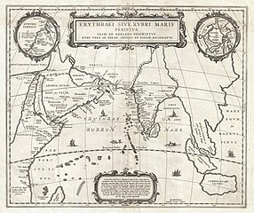
Erythraei Sive Rubri Maris Periplus.
Descripción
English: An unusual and attractive 1658 map of the Indian Ocean, or Erythraean Sea, as it was in antiquity. Composed by Jan Jansson after a similar 1597 map published by A. Ortelius in his Parergon . Covers from Egypt and the Nile valley eastward past Arabia and India, to Southeast Asia and Java. Cartographically, India, Arabia, and Africa roughly correspond to the conventions of the period. Southeast Asia is less recognizable, but the Malay Peninsula, Sumatra, and Java are clearly noted. Most of the place names used throughout are derived from Ptolemy, who himself based his description of the region heavily on records from Alexander the Great's conquests. Two smaller maps in the upper left and right quadrants are of exceptional interest. The upper left chart shows northwestern Africa and is titled Annonis Periplus. This is a reference to the legendary expeditions of the Carthaginian King Hanno, said to have been the first to access the Indian Ocean by sailing around the southern tip of Africa. Incidentally, en route, he is also said to have been the first to tame a lion. The upper right chart shows the northern polar regions as they were perceived at the time. A landmass covering the polar ice cap is indentified as Hyperborea. To the left of this, roughly where North America rests today, the island of Atlantis appears; while Scythia, Europe (Thule) and Asia are on the right. Greenland and possibly Iceland appear at the bottom. This map is intended to point out the possibility of a Northeast Passage to Asia, which was at the time being actively sought after by Dutch, English, and Russian navigators. Both smaller maps, the primary title area at top center, and an Latin explanation for the map at bottom center, are surrounded by baroque strapwork style borders. This remarkable map was published in volume six, the Orbis Antiquus , of Jan Jansson's Novus Atlas .
Fecha
1658 (undated)
Dimensiones
altura: 16 in (40,6 cm); ancho: 19 in (48,2 cm)
dimensions QS:P2048,16U218593
dimensions QS:P2049,19U218593
Número de inventario
Geographicus link: ErythraeanSea-jansson-1658
Fuente/fotógrafo
Jansson, J., Novus Atlas, Sive Theatrum Orbis Terrarum: In quo Orbis Antiquus, Seu Geographia Vetus, Sacra & Profana exhibetur, Volume 6, 1658.
This file was provided to Wikimedia Commons by Geographicus Rare Antique Maps, a specialist dealer in rare maps and other cartography of the 15th, 16th, 17th, 18th and 19th centuries, as part of a cooperation project.
العربيَّة | Deutsch | English | suomi | français | македонски | Nederlands | polski | +/−
Permiso (Reutilización de este archivo)
Esta es una reproducción fotográfica fiel de una obra de arte bidimensional de dominio público. La obra de arte misma se halla en el dominio público por el motivo siguiente:
Public domainPublic domainfalsefalse
https://creativecommons.org/publicdomain/mark/1.0/PDMCreative Commons Public Domain Mark 1.0falsefalse
La postura oficial de la Fundación Wikimedia considera que «las reproducciones fieles de obras de arte bidimensionales de dominio público forman parte del dominio público». Esta reproducción fotográfica, por ende, también se considera de dominio público dentro de los Estados Unidos. Es posible que otras jurisdicciones restrinjan la reutilización de este contenido; consúltese Reutilización de fotografías PD-Art (en inglés) para más detalles.
Leyendas
Añade una explicación corta acerca de lo que representa este archivo
Elementos representados en este archivo
representa a
colección
Geographicus Rare Antique Maps inglés
tipo de archivo Internet
image/jpeg
Historial del archivo
Haz clic sobre una fecha y hora para ver el archivo tal como apareció en ese momento.
{{subst:User:Multichill/Geographicus |link=http://www.geographicus.com/P/AntiqueMap/ErythraeanSea-jansson-1658 |product_name=1658 Jansson Map of the Indian Ocean (Erythrean Sea) in Antiquity |map_title=Erythraei Sive Rubri Maris Periplus. |description=An
اسناد نام خلیج فارس، میراثی کهن و جاودان/فصل ششم:اسناد و نقشه های تاریخی
Histoire du commerce des épices
ペルシャ湾の名称に関する史料、いにしえの永遠の遺産
Участник:Ailbeve/Документы о названии Персидского залива
Enero 17, 2023
archivo, 1658, jansson, indian, ocean, erythrean, antiquity, geographicus, erythraeansea, jansson, 1658, archivo, historial, archivo, usos, archivo, global, archivotamaño, esta, previsualización, píxeles, otras, resoluciones, píxeles, píxeles, píxeles, 1221, 1. Archivo Historial del archivo Usos del archivo Uso global del archivoTamano de esta previsualizacion 715 600 pixeles Otras resoluciones 286 240 pixeles 572 480 pixeles 916 768 pixeles 1221 1024 pixeles 2442 2048 pixeles 5000 4194 pixeles Ver la imagen en su resolucion original 8206 5000 4194 pixeles tamano de archivo 6 03 MB tipo MIME image jpeg Este es un archivo de Wikimedia Commons un deposito de contenido libre hospedado por la Fundacion Wikimedia Mas abajo se reproduce su pagina de descripcion con la informacion sobre su origen y licencia Jan Janssonius Erythraei Sive Rubri Maris Periplus Artista Jan Janssonius 1588 1664 Nombres alternativos Jan Jansson Jan Jansz Jan Janszoon Joannes JanssoniusDescripcion cartografo editor y printseller neerlandesFecha de nacimiento muerte 1588 11 de julio de 1664 1664 Lugar de nacimiento muerte ArnhemAmsterdamPeriodo de trabajo de 1616 a 1664 date QS P 1650 00 00T00 00 00Z 7 P580 1616 00 00T00 00 00Z 9 P582 1664 00 00T00 00 00Z 9Lugar de trabajo Amsterdam 1612 1664 Arnhem 1612 1612 Control de autoridades Q949492 VIAF 34144648241061510121 ISNI 0000 0004 5633 9548 ULAN 500057871 BNE XX1729363 Open Library OL7292024A WorldCat artist QS P170 Q949492Titulo Erythraei Sive Rubri Maris Periplus Descripcion English An unusual and attractive 1658 map of the Indian Ocean or Erythraean Sea as it was in antiquity Composed by Jan Jansson after a similar 1597 map published by A Ortelius in his Parergon Covers from Egypt and the Nile valley eastward past Arabia and India to Southeast Asia and Java Cartographically India Arabia and Africa roughly correspond to the conventions of the period Southeast Asia is less recognizable but the Malay Peninsula Sumatra and Java are clearly noted Most of the place names used throughout are derived from Ptolemy who himself based his description of the region heavily on records from Alexander the Great s conquests Two smaller maps in the upper left and right quadrants are of exceptional interest The upper left chart shows northwestern Africa and is titled Annonis Periplus This is a reference to the legendary expeditions of the Carthaginian King Hanno said to have been the first to access the Indian Ocean by sailing around the southern tip of Africa Incidentally en route he is also said to have been the first to tame a lion The upper right chart shows the northern polar regions as they were perceived at the time A landmass covering the polar ice cap is indentified as Hyperborea To the left of this roughly where North America rests today the island of Atlantis appears while Scythia Europe Thule and Asia are on the right Greenland and possibly Iceland appear at the bottom This map is intended to point out the possibility of a Northeast Passage to Asia which was at the time being actively sought after by Dutch English and Russian navigators Both smaller maps the primary title area at top center and an Latin explanation for the map at bottom center are surrounded by baroque strapwork style borders This remarkable map was published in volume six the Orbis Antiquus of Jan Jansson s Novus Atlas Fecha 1658 undated Dimensiones altura 16 in 40 6 cm ancho 19 in 48 2 cm dimensions QS P2048 16U218593 dimensions QS P2049 19U218593Numero de inventario Geographicus link ErythraeanSea jansson 1658Fuente fotografo Jansson J Novus Atlas Sive Theatrum Orbis Terrarum In quo Orbis Antiquus Seu Geographia Vetus Sacra amp Profana exhibetur Volume 6 1658 This file was provided to Wikimedia Commons by Geographicus Rare Antique Maps a specialist dealer in rare maps and other cartography of the 15th 16th 17th 18th and 19th centuries as part of a cooperation project العربي ة Deutsch English suomi francais makedonski Nederlands polski Permiso Reutilizacion de este archivo Esta es una reproduccion fotografica fiel de una obra de arte bidimensional de dominio publico La obra de arte misma se halla en el dominio publico por el motivo siguiente Public domain Public domain false falseEste material esta en dominio publico en los demas paises donde el derecho de autor se extiende por 100 anos o menos tras la muerte del autor Tambien debes incluir una etiqueta de dominio publico de los Estados Unidos para indicar por que esta obra esta en el dominio publico en los Estados Unidos Esta obra ha sido identificada como libre de las restricciones conocidas en virtud del derecho de autor incluyendo todos los derechos conexos https creativecommons org publicdomain mark 1 0 PDM Creative Commons Public Domain Mark 1 0 false false La postura oficial de la Fundacion Wikimedia considera que las reproducciones fieles de obras de arte bidimensionales de dominio publico forman parte del dominio publico Esta reproduccion fotografica por ende tambien se considera de dominio publico dentro de los Estados Unidos Es posible que otras jurisdicciones restrinjan la reutilizacion de este contenido consultese Reutilizacion de fotografias PD Art en ingles para mas detalles LeyendasespanolAnade una explicacion corta acerca de lo que representa este archivoElementos representados en este archivorepresenta acoleccionGeographicus Rare Antique Maps inglestipo de archivo Internetimage jpeg Historial del archivo Haz clic sobre una fecha y hora para ver el archivo tal como aparecio en ese momento Fecha y horaMiniaturaDimensionesUsuarioComentario actual20 58 23 mar 20115000 4194 6 03 MB BotMultichillT subst User Multichill Geographicus link http www geographicus com P AntiqueMap ErythraeanSea jansson 1658 product name 1658 Jansson Map of the Indian Ocean Erythrean Sea in Antiquity map title Erythraei Sive Rubri Maris Periplus description An Usos del archivo La siguiente pagina usa este archivo Oceano Indico Uso global del archivo Las wikis siguientes utilizan este archivo Uso en ar wikipedia org مقاطعة مليبار Uso en avk wikipedia org India Welfa Uso en bg wikipedia org Indijski okean Uso en co wikipedia org Uceanu Indianu Uso en el wikipedia org Gioxanes Giansonioys Uso en en wikipedia org Arabian Sea Talk Arabian Sea Malabar District User talk A Contemporary Nomad Uso en fa wikipedia org بحث دریای عرب اسناد نام خلیج فارس میراثی کهن و جاودان Uso en fa wikibooks org اسناد نام خلیج فارس میراثی کهن و جاودان فصل ششم اسناد و نقشه های تاریخی Uso en fr wikipedia org Ocean Indien Histoire du commerce des epices Uso en gl wikipedia org Oceano Indico Uso en hy wikipedia org Հնդկական օվկիանոս Uso en ja wikipedia org アラビア海 ペルシャ湾の名称に関する史料 いにしえの永遠の遺産 Uso en lt wikipedia org Indijos vandenynas Uso en no wikipedia org Sjoroveri Uso en ro wikipedia org Documente privind numele Golfului Persic Uso en ru wikipedia org Indijskij okean Uchastnik Ailbeve Dokumenty o nazvanii Persidskogo zaliva Uso en simple wikipedia org Arabian Sea Uso en uk wikipedia org Indijskij okean Uso en ur wikipedia org بحیرہ عرب Obtenido de https es wikipedia org wiki Archivo 1658 Jansson Map of the Indian Ocean Erythrean Sea in Antiquity Geographicus ErythraeanSea jansson 1658 jpg, wikipedia, wiki, leyendo, leer, libro, biblioteca,